The Global Positioning System (GPS) is a worldwide, RF wireless-based system for determining where you are anywhere in the Earth’s surface if there is line-of-sight visibility to at least four of its orbiting satellites. The availability of GPS since its inception a few decades ago has not only enabled products and features which were simply inconceivable before its existence, but it has also changed the way people think about where they are, and what resources they need for location, maps, and travel-direction information. For example, autonomous-driving cars must have GPS to determine where they are where they are going. This FAQ will explore the basic principles of GPS and some of its implementation specifics.
Q: In simple terms, what is the operating principle of GPS?
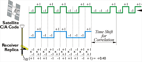
A: The underlying concept is that the user simultaneously receives multiple, precisely trimmed, uniquely encoded satellite signals. By time-aligning (correlating) the received code sequences with the internal receiver sequences, and then performing extensive computations of complex algorithms, the receiver can determine where it is on the Earth’s surface.
Q: How was GPS developed?
A: This short question has a long answer. As in many cases of out-of-the-box innovations, it took a group of “renegade” engineers and scientists to make it happen and prevent the program from being abandoned, largely against substantial official opposition. The story is told in fascinating detail in Reference 6.
Part of the issue was understanding the implications of objectives of navigation versus guidance. ”Guidance” means directing you (or a missile) to a predefined target, and some in the military felt this problem had been fully solved by the extremely accurate, gyroscope-based inertial navigation systems used for aircraft and missiles. In contrast, “navigation” is the challenge of telling you where are along the way, which inertial guidance could not do. In addition, when the concept of GPS was developed, the requisite electronics technology was not available for the satellites and the Earth-based receivers. In fact, the first receiver used to test the concept occupied the entire trunk of a car.
Q: What is the accuracy of a GPS receiver?
A: This question has several answers. A basic GPS system has accuracy of between one and two meters, depending on propagation specifics and performance of some receiver components. There are enhanced techniques such as differential GPS (where the GSP receiver is also linked to a nearby reference location), that can yield position accuracy on the order of a few centimeters.
Q: Can GPS determine the direction in which you are pointing, from a single reading?
A: No. In contrast to a compass, a single GPS reading provides only location, not orientation. But if you move and take a second or series of GPS readings, then you will know its direction.
Q: Does GPS work indoors?
A: Generally not. The very weak satellite-signal at a carrier frequency of around 1 GHz is further attenuated by buildings, roofs, tunnels, and even trees. Local “repeaters” cannot be used since any latency, skew, and drift they introduce would upset the very critical timing of the multiple received signals.
Q: Who manages the GPS system?
A: The U.S. Air Force is responsible for the satellites, the launches, maintaining the system, and correcting the signals as needed as the orbits change (and they do) or other perturbations occur.
Q: How many satellites does GPS require?
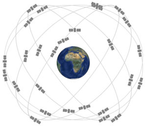
A: To ensure that users anywhere on Earth can have an unobstructed view of at least four satellites (the needed minimum), the GPS system provides an evenly spaced core constellation of 24 medium-Earth-orbit satellites in six different orbital planes, although only 12 are required for full Earth coverage; the others provide more “viewing” opportunities as well as redundancy.

Q: What critical development allowed the idea of GPS satellites to become a reality?
A: Although there were many critical technical developments, one key advance was the availability of the lightweight, low-power atomic clock which each satellite needs for precise timing of its signals. This allows the satellite codes to be sent with extremely high timing accuracy, and is essential to the system performance. Other developments include sensitive, low-noise front-end amplifiers which operate at 1 GHz, and the processing power (via microprocessors or FPGAs) which can implement the complex, intensive algorithms in real time or nearly so.
Q: How is the GPS system organized?
A: There are three functional segments: the control segment, the space segment, and the user segment:
- The control segment includes the master control station which communicates with the satellites as needed, and manages overall system performance and parameters, many of which need adjustment due to inevitable drifts, aging, and orbit shifts;
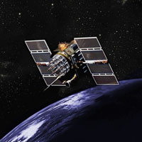
- The space segment consists of the satellites, Figure 2;

- The user segment includes the individual receivers, which are now in the countless millions. These can be freestanding GPS receivers, or receivers embedded into other products.
Q: What is the general nature of the equations related to the received signals?
A: In very simple terms, there are three unknowns: the user’s position in x, y, and z (or their polar equivalents). By correlating the received signals in time, the time delay and thus the distance between each satellite and the user can be determined, in principle. The position could be determined using the time-alignment of just three satellite signals; in other words, there are three equations and three unknowns. However, the clock in the receiver is a low-cost, not-very-accurate crystal-based unit, so the fourth satellite signal is intertwined with the basic equations to allow a correction of the receiver time base. By using four satellite signals, there are four equations for the four unknowns (x, y, z, and time), and this allows for simultaneously solving the quartet.
Q: What are some of the specifics on the satellites of the space segment?
A: The satellites are in near-circular orbits at a height of about 9476 miles (15,250 km), as no orbit is perfect; all orbits are affected by the Earth’s spherical imperfections. The orbits are at a 55⁰ inclination to the equator, so there is full coverage of the Earth’s surface, and have an orbital period of about 12 hours. Each satellite carries two atomic (cesium) clocks plus a third as spare. The satellite uses two signal carrier frequencies in the L-band, one at 1.57542 GHz and the other at 1.22720 GHz; two signals are used to allow for corrections due to differences in ionospheric propagation delays.
Q: What is the nature of the encoding for the transmitted signals?
A: The satellites use pseudorandom sequences (PRSQ), which are resistant to noise and corruption, and easier to correlate, Figure 3. There are actually two such PRSQ sequences: the P-code pattern is long and provides more time-alignment, while the C/A code is shorter and less precise, but supports faster acquisition and analysis. Timing of these signals must be accurate and measurable to nanoseconds for GPS to be useful.

Q: What about the control segment?
A: The control segment must not only communicate with each satellite, but it must also determine what imperfections and changes the satellite orbits have undergone. To do this, there are multiple Earth-based stations at locations known with extreme accuracy and precision. Each base station uses radar and other techniques to ascertain the details of the orbit of each satellite.
Q: What are some details of the receiver segment?
A: The receiver segment will be discussed in more detail in Part 2.
Q: There are GPS-related terms such as GLONASS, Galileo, BeiDou, and QZSS. What are they?
A: These are GPS-like systems developed and operated by Russia, Europe, China, and Japan, respectively (QZSS, for Quasi-Zenith Satellite System, is not global but covers a Japan-centered region and needs only 4 satellites). Although they use different frequencies and PRSQ coding sequences, and differ in many other details such as modulation formats, they are based on the principle of orbiting satellites transmitting precisely timed code sequences which must be received, resolved, and adjusted to determine position. Each system has individual characteristics which offer relative pros and cons in terms of accuracy, range, coverage, resistance to noise, and other factors.
Q: I don’t see GNSS on that list. What’s the difference between GPS and GNSS?
A: GNSS is short for the Global Navigation Satellite System and is a generic term for any satellite-based navigation system. A user who is equipped for GNSS can switch to another global satellite system if the one they are initially using fails or is subject to weak signals or interference.
Part 2 of this FAQ looks at some hardware circuitry used to implement a GPS receiver as well as the unappreciated role that Einstein’s Theory of Special Relativity plays in providing an accurate GPS.
References:
- GPS: The Global Positioning System (Official US Government Site)
- “Relativistic Effects in the Global Positioning System,” July 18, 2006.
- “Relativity in the Global Positioning System,” Living Reviews in Relativity, January 2003.
- “Relativity and the Global Positioning System,” Physics Today, May 2002.
- Richard H. Battin, “An Introduction to the Mathematics and Methods of Astrodynamics,” ISBN: 978-1-56347-342-5, American Institute of Aeronautics and Astronautics.
- Greg Milner, “Pinpoint: How GPS is Changing Technology, Culture, and Our Minds“
- Neil Ashby & Marc Weiss, NIST Technical Note 1385, “Global Position System Receivers and Relativity”
- Pennsylvania State University, John A. Dutton e-Education Institute, “The GPS Signal”
- Maxim Integrated, Application Note 3447, “Complete Stand-Alone GPS Receiver Solution with MAX2742”
- STMicroelectronics, STA8088CWG Data Sheet
- STMicroelectronics, GNSS, UM2399 User Manual
- EEWorldonline, “Open-source GPS/GNSS-aided inertial navigation software stack handles precise navigation apps”
- EEWorlonline, “Autonomous vehicles: “We don’t need (necessarily) no stinkin’ GPS”
- EEWorlonline, “Multi-constellation antenna targets automotive apps for location tracking, GPS, GLONASS, and BeiDou bands”

